Total Pageviews

Monday, 25 September 2017

Derwent moors

24/09/17.

As I am working nights this week I found myself lucky enough to have a few free hours [ me time]. The best thing to do with "me time"is to go for a walk. We chose a lovely little short but scenic circuit from Cutthroat bridge in Derbyshire...This is the starting point for many a fine walk. A rather macabre title for a bridge, it is said to be named after an incident in 1635 when a traveller/ merchant was found here with his throat cut from ear to ear. He would have been travelling on an old pony route through the high ground between Sheffield and Manchester. All his goods and money was gone/stolen but amazingly he was still alive and was taken to nearby Bamford hall, where he died a few days later.
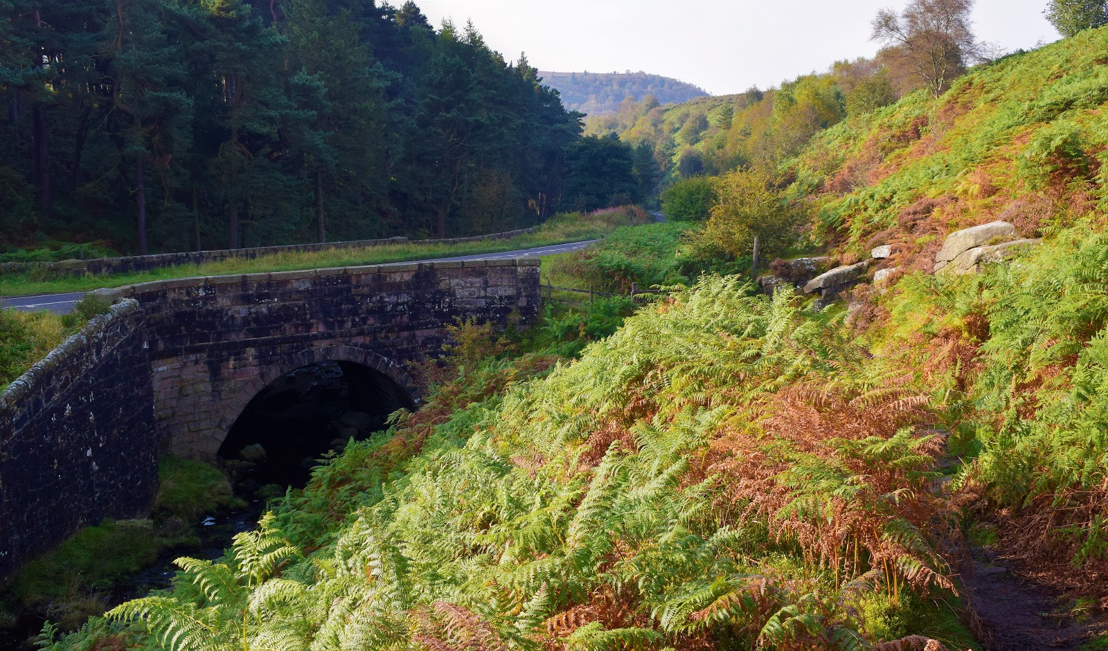

Weather wise it was turning into a beautiful day, early autumn tints of gold begin to take over as the bracken was on the turn up on the moors...This has always been a special time of year for me. We crossed the stream and set off in the direction of Moscar. Todays walk was taken from a little book called Short walks in the Peak District. Some nice little walks in this book, I hope to be making my way through them during the coming months.


At Moscar the route turned westward across the moors following an  ancient path towards Derwent edge. before crossing the moorland I popped over to have a word with a lovely friendly horse..he told me he was having a great day in his field with his friends the sheep.


Crossing the moor we came across this ancient standing stone/Menhir..it stands in a lonely spot looking out towards Stanage edge. Cant find out much about it, probably a guide stone across the moors. I read somewhere that it was once knocked over years ago by an irate landowner who dislike people crossing the moor.


Before long we found ourselves at the Moscar/Derwent/Derent edge crossroads...This is a popular place for walkers and rightly so. Everyone that walks in the Peak district finds themselves drawn here again and again. To our right lay the massive gritstone outcrop of the wheel stones sometimes called the coach and horses..Our route turned left towards Whinstone lee tor.


I like Whinstone lee tor...I always have, I consider it to have one of the finest views in the whole peak. A hazy view today. Heres the view looking down to Ashopton viaduct with Win hill in the background.


Downhill from here towards Ladybower where we skirted around the side of the hill, passing above the Ladybower inn...Nearly back to the car now, although we still had the beautiful Ladybower wood nature reserve to walk through. It is one of the few remaining examples of ancient sessile oak woodlands in the Peak district. A real joy today, woodland at its very best.


Sunday, 17 September 2017

Marvellous Mardale...A walk up to High street.

September 16th 2017.

Todays route started from Mardale head at the end of the isolated Haweswater reservoir. It's quite a quiet area by lake district standards, although several walkers cars were already parked up when we arrived at about 8.30...The plan was to tackle the Rough crag ridge, so off we set. There are some great looking mountains here at Mardale head, the one that demanded the most attention being Harter fell, a tremendous wall of crags falling swiftly down into the head of Mardale amid wild and romantic surrounding...We pressed on along the northern shore of Haweswater. I looked back often, Harter fell I couldn't ignore.

We rounded a bend on The Rigg and were greeted with our first sight of the neighbouring valley of Riggindale, a quiet secluded valley. The valley holds a special place in the hearts of birdwatchers as this is Golden Eagle country...Or rather I should say was Golden Eagle country as the male Eagle that was resident here has not been seen for the last couple of years...such a shame, would have been amazing to have seen an eagle wheeling above the valley....I do hope they return one day.


As we climbed we began to get better views out across Haweswater, it amazed me how blue the water looked...

I enjoyed the walk along the Rough crag ridge. It has been referred to as the connoisseurs route to High street, the ascent is a classic. Ahead lay the rocky staircase of Long stile with the Whale-backed crest of High street beyond..With an excitable Spaniel on a lead I set off onwards and upwards, I would need a breather at the top.


Yep...a breather was need as I stumbled up onto the plateau...what a view though looking back along the ridge.


The small tarn of Blea water looked amazing from up there, cradled between rocky arms its said to be the deepest tarn in Lakeland,200 ft deep apparently, it certainly looked dark and mysterious.


Only a short walk now up to the 2718ft summit of High street. Many of the high places of Lakeland have no place in history books, this cannot be said of High street though, as a Roman road crosses the fell, a high level route between Ambleside and Penrith, I bet there are many ghosts of Roman centurions up there. The summit is also known as Racecourse hill and would have been the venue of huge gatherings of shepherds from all of the surrounding valleys who would meet up to exchange lost sheep. At these shepherd meets there would be much drinking, merriment and wrestling, pretty much the same that  go's on in other High streets up and down the country...Nowadays all is quiet here and only the rising larks disturb the stillness.


With another Wainwright ticked off my second round list I headed off to the next Mardale ill bell. Standing at 2496ft..Great views back to Haweswater from up there.


All that was needed now was to descend to the Nan bield pass then drop down the rocky staircase to Small water [another tarn].before following the path back to Haweswater...not that easy though when your old legs, knees, ankles are shot...I hobbled along, then suddenly found my self laying on my back as I slipped into a disgusting black bog...Just as a group of people passed me,[why does it always happen when people are passing]...Pointing at the dog I said "I'm in competition with him to see who can get the filthiest". Im sure it wont be the last time that happens...What a classic walk it has been.

Monday, 4 September 2017

The gorgeous Harter fell..

We were lucky enough to find ourselves with a couple of free days, "best not waste them" we said, so we drove up to the Lakes for a couple of days of walking and camping. We chose to camp in Eskdale, as its any area we rarely get around to visiting...The campsite was to be Fisherground situated mid way along the valley...It was ok, but not a site I would recommend [too many rules and too many kids running around causing havoc]. I suppose its my age but I much prefer the quiet life...The day of our walk dawned, overcast, never mind....We drove up the valley to the small car park at Wha house farm. A footpath sign at the car park pointed its way up to Scafell via Slightside and just for a second I was tempted. Across the valley the craggy and pyramidal summit of Harter fell looked fantastic...The long slog to Scafell or the beautiful climb up to Harter fell, there was no contest...We set off along the lane towards Harter fell.


We walked on to the bottom of the Hardknott pass, several cars were parked here,and i realised we could have saved nearly a mile of walking along tarmac to get here.Never mind the road was quiet so it really didn't matter. We crossed over Hardkott gill at Jubilee bridge to follow the lovely path that crosses the fells over to Dunnerdale.....Good views began to open up as we climbed across the valley towards the Scafells and Upper Eskdale.


The path to Harter fell leaves the main path, indicated by a small pile of stones and sets off much steeper now, through thick bracken at first but this is soon left behind to follow a sketchy path across the eastern flanks of the fell.I love to follow a path like this...patches of heather now added to the beauty of the walk.


Nowhere was the path too steep..The only sound we could here were the bees busying themselves with the Heather, Then suddenly from nowhere peace was shattered as two jets flew below us, the sound was startling almost deafening but within seconds they had disappeared, across Dunnerdale then over the Coniston fells...Peace returned....A short steep section and we were topping out on the summit,first we visited the Trig pillar.


There are three rocky tops on the summit and it is customary to visit all three, the first, where we find the pillar is not the actual top. Nearby is a far rockier little top, the true summit at first glance it looks an unassailable climb, but to the north of it there is a breach in rocks giving an easy scramble to the 2140ft summit...I think the views from Harter are as good as anywhere in the district, but everyone has there favorites...After scrambling the rocks we settled down for a bit of scran and a cheeky Vimto..We sat with our backs to rocks looking down across the Duddon valley towards Cockley beck and the Wrynose pass[pictured below].

After a leisurely break we retraced our steps back to Eskdale. Taking our time as the views were first class. We remembered the last time we walked up to Harter fell, many years ago in thick fog being led up by our daughter Emma who had recently climbed it on a school trip. Sadly on that day we had no views but today was a different Kettle of fish.To the south towards the glittering Irish sea sea we could see Black coombe, The Duddon estuary, Little Stickle pike, To the east the huge range of the Coniston fells, The the west we had Birker fell, Green crag, Devoke water and Muncaster fell and finally to the north stood mighty Pillar the Scafells and Bowfell..all in all a sight to stir the soul.


We more or less had the fell too ourselves which is just as I like it..However at times it is nice to meet fellow walkers... at Jubilee bridge we met up with a little Japanese man who had been up to the summit, we walked back with him along the road, a chatty little fellow from Crewe, I enjoyed his company, Its always nice to have a chat with kindred spirits.

Sunday, 27 August 2017


White Nancy and the Saddle of Kerridge.

A short walk to start my ten days off work...Oh how I love being a lazy workfree bugger. Todays walk started from the lovely,little,laidback town of Bollington in Cheshire. Tucked away in the folds of the hills just outside the western edge of the Peak district national park. Being outside the park doesn't seem to bother Bollington the beautiful countryside around these parts are as nice as anywhere..We parked up near the Crown public house and set off...Rubbing my hands I said "That little beauty will be open by the time we get back". We could see White Nancy peeping at us over the brow of the hill, but we turned left, we would visit her on our return...The sun was smiling down on us as we climbed away from the village.


We skirted along the Eastern edge of the ridge as far as the village of Rainow, Nothing much to report along here, apart from lovely views and the swooping Swallows...They will be off soon on their long trip south to Africa...Spoke to a chap who was walking to Congleton and back via the Gritstone trail and Macclesfield forest. Good luck with that I said as I wiped a bead of sweat from my brow...boy it's hot today...We climbed up to the southern part of the ridge and were instantly treated to views in every direction.

To the west we had The cloud, Macclesfield [pictured] and the Cheshire plain with the Peckforton hills and Welsh mountains away in the far distance.

And to the east we had the beautiful prospect across the River Dean valley to gentle rolling hills backed by the hills of the Peak district...A very pleasing scene..i enjoyed it up there along the crest of the  Kerridge ridge, the ridge gets its name from Key ridge from the old English Caeg hrycg..Standing at around the 900 ft mark every step is a pleasure....We also noticed footpath signs for a new walk that has recently been devised by the friends of the Peak district called The Boundary walk..a 190 mile route keeping to the perimeter of the Peak district...oh to be fit again, I suppose I could do it in short sections [very short sections]...Us old walkers never give up. we hobble on always....Back to the ridge I noticed it was alive with Knapweed and Harebells, so I spent several horizontal minutes trying to photograph them.


I spoke earlier of White Nancy peering down on us, well we eventually caught up with her at the northern extremity of the ridge...It was like entering a party uninvited as there were several folk up there having a whale of a time..lots of frolicking and picnicking...it was hamper to the left, blanket to the right...good to see people enjoying the countryside, especially children as these are the walkers of the future, they will be looking after all things rural long after we have pegged it...so if anyones reading this that has children, you must get them out there at every opportunity...it really is important. If we all turn into couch potatoes then that's it for the English countryside.


So what exactly is White Nancy..in short a folly, built in 1817 by a local man called John Gaskill, some say it was built to commemorate the Battle of Waterloo..In those days it was a hollow structure where folk could sit down to admire the view but it has long been filled in and rendered, standing at around 18ft high it is regularly given a fresh coat of  whitewash by the good people of Bollington...More often than not it is emblazoned with an eyecatching design such as poppies or the Olympic rings at the moment there is an outstanding Manchester Bee on it...with the words Hope,strength and peace to commemorate the terrible terrorist attack in Manchester..Back down in Bollington I was pleased to see that the doors of The Crown were flung open, for all us thirsty walkers. We ordered a sandwich to have with our pints...we witnessed some proper Northern hospitally as they also brought out chips for us saying they had fried them by mistake and that we could have them free of charge..lovely people, most places would have just thrown them out....


Sunday, 20 August 2017

A wet day on Bowscale fell.

Fancied doing something on the Northern fells, Bowscale fell sort of jumped out at me. Must have been over 20 years since I last climbed up there. I remember following a scrambling path from Mungrisedale  up through Gorse and Bracken to reach the 2306ft  summit via the east ridge early one summers morning. I recall continuing on to Bannerdale crags and returning over Souther fell before returning to the tent for breckie....Hey we could do that again I thought, but this time I also wanted to visit the fabled Bowscale tarn en route....I will be great I thought,i thought about it again and again....2 weeks I have been thinking about it, cant wait.

We left Doncaster at 5 am..beautiful blue skies, but we had a feeling it wasn't going to last. The feeling was right, as we passed over Stainmore into Cumbria it all took a turn for the worse, I drove the length of the Eden valley with windscreen wipers going full pelt, they still couldn't take it and at one stage we had to slow down to a crawl...it will pass I said,by the time we get to the Lakes....Fingers crossed. We pulled up into the little layby at Bowscale, it was clearing up [a bit]. Best put waterproofs on just in case.

No sooner had we left Bowscale and the bastard rain came down big style...I mean real rain, I tried sheltering behind walls, I tried sheltering behind Karen...I sort of lost it and shouted every four letter word I know at it. But still it rained...don't get me wrong, I quite like rain, but not when you are trying to take photographs, not when you have been looking forward to a walk for 2 weeks...Anyway, not going to go on about it, carried on along the track towards Bowscale tarn. This was once a popular route in days gone by, Victorian ladies would have been escorted along here on ponies to visit the tarn. It would have been part of many folks grand tour of the Lake district. Today it is much quieter, just daft buggers out bagging peaks or even dafter buggers going for a wild swim in the tarn.

We arrived at the Tarn, a beauty that sits in a craggy glacial combe. This was going to be the highlight of my walk, but not in this weather. I had planned on a paddle,or a refreshing wild swim, but not in this weather...Bowscale tarn biggest claim to fame is that 2 immortal trout live here...William Wordsworth wrote about them in a poem...No sign of them today though...As I say, this was going to be the highlight of the walk, but I think we stayed all of one minute before pushing on. Steeply uphill now following a grassy rake towards the edge of the combe, I had hoped for a shot of the tarn from above but the camera was put away into my rucksack...I felt quiet pissed off


We trudged on towards the summit shelter...it was blowing a hoolie up there, it literally felt like people were throwing buckets of water over us...soaked through by now. All fell walkers will know this situation well.


We banished all thoughts of continuing along the ridge to Bannerdale crags and took the wimps route down alongside The Tounge headed down to Mungrisedale..Things began to clear up a bit and we were treated to some lovely views of Bannerdale. These views make everthing seem worthwhile..I kept looking back up to Bannerdale crags. In a way I wish I had continued up there, I felt that we had failed to do the walk. Karen said its not a race, not a competion and she is right, those other hills aint going nowhere, they will still be there for future visits.


Nearing the valley saw evidence of the power of Mother nature as the path beside the Glenderamakin river had been washed away and the bridge over Bullfell beck was teetering on the brink of collapsing. A soggy boggy detour was asked for.


We trudged back along the lane from Mungrisedale to Bowscale...I suppose it was quite a good day. But then ive never known a day in the Lake district that wasn't.

Tuesday, 8 August 2017

August 5th 2017..Up,over and around Gowbarrow fell.

"Been sitting around too long we need to get back to the hills for some serious walking" i said to my wife Karen...... A few years back on my 50th birthday I finished my round of Wainwright fells, it was a sunny day in March, a day I wont forget in a hurry, finishing off with the summit of Mellbreak. Since then the bagging of hills has been put on the backburner,occupying my time with long distance paths such as the Pennine way,Cleveland way and a few local walks around the Peak district...but the call of the fells is too strong and now they are calling me back.
Today we have chosen to walk to the top of Gowbarrow fell. It is always exciting to wake up and instantly think "HILL DAY"...Its quite a drive from where we live up to the lakes but it is always worth it.We pulled into the High cascades car park just south of the village of Dockray. The sun was out and all was fine and dandy. It has been many years since I climbed Gowbarrows slopes and time had blurred my memory so it felt like a new hill to me...A lovely sight greeted us as we started our walk as we passed through a group of the most beautiful horses I have ever seen, they didn't bat an eyelid at Alfie [ our Springer] I think they liked him  and I think Alf like them too.
It was downhill to cross the Aira beck then a left turn to slowly gain height, I noticed a sign for the Ullswater way, not a walk I am familiar with, I shall be looking it up when I get home I thought to myself.
Onwards and upwards now as we climbed gently up the heathery slopes of the fell,nowhere was it too steep, no difficulties. Looking back we were treated to a nice view back down to Dockray, the weather seemed to be changing and we noticed rain heading our way
Somehow it missed us and the blue skies soon returned, in no time at all we were stood on the summit.We leant against the trig point to take a traditional selfie. The summit is set too far back for any great views over Ullswater. My fave view was looking north towards Little mell fell a beautiful scene.
We had only come a couple of miles from the car park but by now we were buzzing.Sadly though it was downhill from here but we still had much to look forward to. We followed the path down through slopes of bracken until we came to the path that traverses the eastern side of the fell. The views across Ullswater were second to none. We stopped here for a coffee and a butty on a little rocky outcrop, could have sat there all day.
It was heaven sitting there looking out across the water to the Far eastern fells,the High street ridge at the back with Hallin fell and  the emerald green fields of Martindale in the foreground. after half an hour or so we pushed on, wondering what was round the next corner. In all my visits to the Lake district I have never followed the path along the side of Gowbarrow before, its now a path I would recommend to anyone as every step is a delight, a surprise around every corner.....It certainly was a surprise when we rounded Ivy crag to be greeted with this lovely atmospheric view up along Ullswater.
Once again luck was on our side as the rains somehow missed us. This view was the view of the day for me....dropping down more steeply now. The walk still had something to look forward to though as we were nearing Aira force waterfall...we knew we were getting near by the amount of people that we met, from the one or two folks we saw on the fell we know came across dozens upon dozens of folk...on the bridge below the waterfall I had to push my way through about 50 people to get this shot of the waterfall.
From here it was back uphill alongside Aira beck..things slowly got quieter, back at the start the horses were still standing quietly by the gate...The walk was only about four and a half miles but it took us about 4 hours which was perfect as we don't like to hurry...slow down and enjoy each moment..back at the car I congratulated Karen on her 136 Wainwright top and I congratulated myself on my 29th second round top...aye its been a grand day.