Total Pageviews

Wednesday 30 May 2018

The summit of the Howgills from Cautley.

24/05/2018.

Scorchio!!..what a day for a walk...We were camping at Low greenside farm at nearby Ravenstondale,when we decided to have a walk in the Howgill fells. Such a lovely area for walking and reasonably quiet,the fells are sandwiched between the Lake district and the Yorkshire dales, far less touristy but just as beautiful. Its a walk we have done before, a year or so ago, but on that day it rained from leaving the car and the mists came down so we couldn't see a sausage. Its said to be the best area for walking in the Howgills, with the best scenery....so off we went.

We parked up in the layby beside the Cross keys pub, always handy to have a pub to call into at the end of a walk..However not for us today though as this 500 year inn is a Temperance inn, so its a pub that doesn't sell alcohol, whoever heard of anything so ridiculous. We shall have to wait until we get back to Ravenstonedale for our end of walk pint...From the layby we dropped down to cross an attractive little footbridge across the river Rawthey. The massive bulk of Great Dummocks lying ahead [ we will be up there later on the walk].


Rounding a corner and we got the first views of Cautley spout waterfall tumbling down the fellside its a most impressive sight set in a tight ravine, it was some way off yet in the distance, but we could still hear it.


Its the highest waterfall in England. The broken cascade of falls tumble downhill for 650 ft. It became more and more impressive as we neared it...The bloody steep climb alongside it seemed never ending on the hot day.


Luckily there is a stepped path, it was a case of 100 steps, stop for a breather...100 steps, stop for a breather...100 steps, stop for a breather..we eventually made it up to the top where the falls tumble over a lip of rock, a lovely spot in the hills.


We gazed across the valley towards Yarlside, it looked fantastic, I wanted to get up there and walk those grassy slopes, not today though, come on we cant stand here all day. We followed a decent path up alongside the beck. Alfie was in his element plunging into many of the pools along here, many of the deep enough to swim in..We thought about joining him but the nearest we got was a paddle, blooming freezing but boy did it freshen you up and make you feel great.


Pressing on we eventually made it up to a col between the hills to the left lay Calders and to the right lay the Calf..it had to be the Calf...Mecca for all those that walk the Howgills..at 2218ft above sea level it is the highest ground amongst these fells....The summit commands an extensive view from the long sweep of Lakeland mountains down to Morecambe bay and across to the Yorkshire three peak country...We had a lunch break here ...we sat and looked...and dreamed.


There is a small dryed up tarn on the summit where a path heads off in the direction of Yarlside...we looked but couldn't find the path anywhere so headed off back in the direction of Calders,then heading off across moorland in the direction of Cautley crags where I knew there was a decent path back to the waterfall..Whernside, Ingleborough and Pen y Ghent held my attention here as we crossed swathes of cottongrass, nodding in the breeze.........Suddenly and without warning, we were standing on the very edge of the crags..a supreme moment, one I will never forget, for there in front of us lay the best view I have ever seen in all my years of walking...I must have said "I cant believe this" a dozen times, possibly more..my camera went into overdrive.


I could have sat there all day...I reckon its a view that few know about...We walked back along the top of the line of crags...slowly...very slowly..this was too good to hurry,on walks this good every second should be savoured.


Eventually made it back to the top of the waterfall where we retraced our steps downhill, back to the river and the car..should be have a cup of celebratory tea in the cross keys...Nah sod that... this walk needs celebrating properly with a pint in the Kings head at Ravenstonedale....so that's what we did...Cheers...Heres to the Howgills...may my love affair with them long continue.




Friday 25 May 2018

Two Wainwrights from Mungrisdale.

23/05/2018.

We have a couple of free days to go walking in Cumbria, we are being well and truly treated, with beautiful warm May sunshine. But where to go,certainly no shortage of choices. We remembered our last trip up here when we got a right old drenching on Bowscale fell a day that we had a longer walk planned but due to the weather called it a day. "I would like to go back to climb the other two Wainwright fells in the area" I said.   Sorted, Bannerdale crags and Souter fell it was to be then. Not a cloud in the sky as we left the village of Mungrisedale...Heading up to Bannerdale, this had the makings of a great day


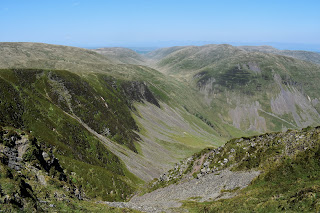
We were following the route that we had taken off Bowscale fell, Water squirting from our boots that day. None of that today. Bannerdale crags,the days first objective can be seen in the picture above [ on the left]. Its a decent path,not too steep which is just as well in this weather.We plodded on up to the ridge where we took a well earned breather.


The 2241ft summit seemed close by now along an easy path along the ridge. The summit of the fell is smooth and grassy with a cairn set well back from the crags..Some great views along here.


Its been a few years since I have walked up here, the last time was probably over 20 years ago while we were camping at Pooley bridge. I must have been fit in those days, we came up to the Lakes most years Wainwright bagging. I used to think nothing about getting up at 4 in the morning, do a couple of fells before breakfast. then another walk during the day..Those days are well and truly gone now, just glad I can still get out and do it although at a much gentler pace...We stood on the summit taking it all in, realising I had no map on me I tried to recall how I got down to cross the Glendaramakin river but couldn't remember so we were going to have to wing it...Heading off in the direction of Blencathra which looked so close that you could reach out and touch it. Tiny figures could be seen scrambling along Sharp edge. Karen didn't like the idea of guessing the route so we decided to change the route. We would go and visit the summit of Mungrisedale common instead.


We met a couple on the way that told us that the route was dry and that there was just one boggy patch that could easily be walked around..This is rare because the fell usually resembles a quagmire. Yes it was reasonably dry even the wet patch could be easily walked across..i turned to see Karen dithering, "come on walk across it" I said....she did and ended up knee deep, you can always trust Karen to find the wettest spot...This is said by most to be the most boring Wainwright fell of them all, I wonder why he included it on his list?..its not that boring and the views of the northern fells are superb...Thunacar knott gets my vote as the most boring..I remember Old Wainwright said of the fell.."It has no more pretension to elegance than a pudding that has been sat on".


All that was asked of us now was to retrace our steps..going back the same was is no hardship on a walk this good as you get to enjoy all those views again...And no walk is complete until you visit the pub at the end luckily The Mill was open for a pint of the local nectar...I wont forget todays walk in a hurry.


Tuesday 8 May 2018

Slackhall to Hayfield along the Peak District boundary walk.

06/05/2018.

Smack bang in the middle of a spell of hot and settled weather, we knew from the start that todays walk was going to be a classic. We are wearing brand new boots today,so we hoped we wouldn't be hobbling and blistered by the end of our trek, but having said that boots are far easier to wear in these days than they were years ago. We eventually found a parking space near the Chestnut centre, which sadly has closed to the public, it used to be an Otter and Owl wildlife park but as from last December has closed down due to the retirement of the owners. We had about half a mile up a quiet lane to pick up the Peak district boundary walk where we left it last time..It was only early and the sun was beating down already, thankfully I was wearing shorts and sheltered under a wide brimmed hat. I think my lily white legs might take a battering from the sun today. Ahead of us lies South Head, one of my favourite hills in the Peak district. It seemed a long way off.


We passed through an area of most attractive countryside, lush green pastures. We wondered why we had never ventured this way before. My jaw had well and truly dropped by the beauty of it all. And all this a few miles from the town of Chapel in le frith. Beauty like this remains in your memory forever.


Over the fields and far away our next objective was the Pennine Bridleway, a National trail that runs up the length of Northern England for a distance of just over 200 miles, Starting in Derbyshire and finishing in Cumbria it provides excellent access for those on horseback as well as cyclists and walkers. The section we walked today being familiar ground to us as we have passed along here many times. Its fairly rocky in places, don't think I would like to cycle along it...can you imagine cycling along a rocky track with a headache?...Also lots of puddles along here which Alf [our dog]was most happy about.


At South head we had the option of going round the hilltop on the bridleway or going steeply over the top. Yes you've guessed it, I wanted to go over the top while the others went round...Lifes too short not to go over the top, Hilltops are special places and are always worth visiting. And the views from the 1621ft summit are just superb.Its a lovely little top with a well built cairn and 360 degree views taking in some cracking hills, From Black edge,Shining tor, Chinley churn, Mount Famine, round to Kinder scout, Kinder held my gaze for quite awhile...I drifted off, deep in my thoughts,before snapping out of it and returned to the walk.


Theres a little Tarn on the col between South head and Mount famine where we paused a little while to allow Alfie to enjoy a swim, take a drink and generally cool down a tad, He would have another dip later in the River Sett. On the walk down to the valley we were again treated to great views, I consider this view [ next picture] to be one of the very best in the whole of the Peak district.


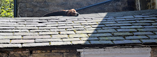
At Bowden bridge we decided to call it a day along the boundary walk as this would make a good place to carry on from next time. Before heading back we chose to nip into the Sportsman pub for some Liquid sustenance. A pint of Thwaites Lancaster bomber hit the spot exactly where the spot needed hitting, and the Three cheese and red onion pie was to die for. We drank and ate in the beer garden under the watchful eye of a dog sitting on the roof.


Heading back now and still feeling fresh we opted for the detour that is Mount famine, so glad we did the breeze was beautiful as we sat for a Satsuma break soaking it all it. I would have loved to have layed back closed my eyes and fallen asleep listening to the Skylarks [ but Karen wouldn't let me] She wanted to get going..oh well onwards it is...Oh and I also heard the years first Cuckoo from up there...Magic.


We walked back at a lesuirely pace, This was certainly the best part of the PDBW so far.